Interestingly, the stations are not in Shanghai municipality but in Kunshan city in neighbouring Jiangsu province. In future the line will connect to Kunshan's own metro system.
We've updated exploreshanghai.com and updates for our iPhone app and Android app will be available soon.
We're delighted to announce that Explore Shanghai Metro map 10.0 for iOS is now available in the App Store! We've redesigned the app to match the style of the new iOS7. You'll notice a much lighter feeling around the app, with more whitespace and semi-transparent glass effects, thinner fonts and icons.
Although the app looks best on iOS7, it will still run on any device (iPhone, iPod touch or iPad) running iOS5.1 and higher.
As this is our first release for iOS7, there may be a few rough edges - do let us know if you see anything broken. A 10.1 update will be available soon, which fixes the missing legend.
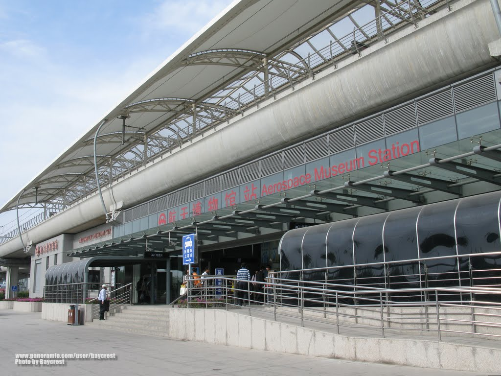
The station at the southern terminus of Shanghai Metro Line 8 has been known as Aerospace Museum since it opened in 2009. There's just one small problem: the museum of that name doesn't actually exist yet.
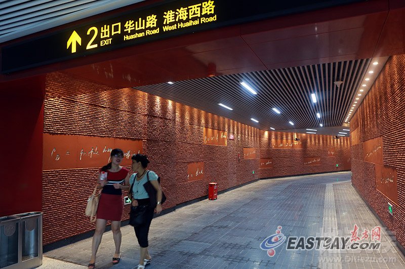
Four years later, it's unclear if the museum will be constructed at this site, and so the Shanghai Metro company has decided to fix this by renaming the station to Shendu Highway (沈杜公路). We've updated www.exploreshanghai.com with the new station name, and the name will also be updated in the next updates to our iOS and Android apps.
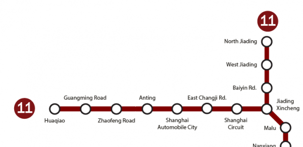
Good news... the Shanghai Metro is about to get even longer! The Shanghai Metro company has announced that the extension to Line 11 will open on Saturday, August 31 2013.
While the current Line 11 links the northern suburbs of Anting and Jiading with Jiangsu Road station, the new line will add 12 new stations south of Jiangsu Road. The line first heads south, intersecting with Line 10 at Jiaotong University and Line 1 and 9 at Xujiahui.
It then heads south with 4 more stops in Puxi, at Shanghai Swimming Center, Longhua, Yunjin Road and Longyao Road, before heading into Pudong with stops at Oriental Sports Center (Line 6 & 8 interchange), Sanlin, East Sanlin, Pusan Road, Yuqiao and Luoshan Road.
The full list of new stations is:
Jiaotong University 交通大学
Xujiahui 徐家汇
Shanghai Swimming Center 上海游泳馆
Longhua 龙华
Yunjin Road 云锦路
Longyao Road 龙耀路
Oriental Sports Center 东方体育中心
Sanlin 三林
East Sanlin 三林东
Pusan Road 浦三路
Yuqiao 御桥
Luoshan Road 罗山路
Several of the new stations have designs inspired by their locations: Longhua has a gold roof inspired by Longhua Temple while Jiaotong University Station has a literary theme, with artworks based on manuscripts belonging to scientist Qian Xuesen.
Luoshan Road, the new eastern terminus will be a interchange station with Line 16, anticipated to open at the end of this year. Line 16 will carry on further into Pudong, terminating near Dishui Lake.
Back in 2010 I analyzed the passenger numbers on the Shanghai Metro's twelve lines. Earlier this year the Shanghai Metro company released new data, which allows us to compare the growth in passenger numbers across the different metro lines.
With a 38% increase between 2010 and 2013, Line 2 has overtaken Line 1 to be the busiest line in Shanghai, with 1.65 million daily passenger rides. The biggest increase was Line 10, which rose by more than 5 times, from 120,000 to 680,000 - although it's worth noting that Line 10 had heavily restricted trial opening hours in 2010. Line 9 and 11 have also seen a near-doubling of traffic.
May 2013 brings two new openings for the Beijing Subway! Beijing Subway Line 10, a major loop line around the city opened at the start of 2013, but two stations were missing. Those two stations: Fengtai Railway Station and Niwa are now ready for passengers. That means you can now take a subway train all the way around the loop - a full circuit takes over 1.5 hours! Train frequency has also been increased to a headway of 2 minutes 15 seconds at peak times.
There's also a brand new subway line, Line 14 heads west from Xiju station (interchange with line 10), running 12.6km to its terminus at Zhangguozhuang (张郭庄). Line 14 has 6 stations in the initial phase, all in Fengtai District; trains do not currently stop at Qilizhuang station (七里庄), which will be a future interchange with Line 9 and should open by the end of 2013.
One of the main reasons to take Line 14 is to visit the Beijing Garden Expo. There's a dedicated station, Garden Expo Park, for accessing the Expo.
Here's a map of the new stations! Stay tuned for updates to our online map and apps for iPhone and Android shortly!
The Shanghai Metro is one of the longest metro stations in the world. How stations does it have, as of December 2014? That's a slightly tricky question to answer, for a number of reasons:
Which lines to include?
For the purposes of this article, we're including the fourteen lines which provide regular metro service: that's Lines 1 through Line 13 and Line 16.
We don't include the Jinshan Railway ("Line 22"), as the frequency of trains on the line is not high enough to constitute a rapid transit service, and there is no integrated ticketing with the rest of the network. Similarly, we exclude the Shanghai Maglev train.
Which stations to include?
We include all currently open stations.
There are two stations called Pudian Road, on Line 4 and Line 6, but they are geographically separated with no way to interchange. We therefore treat these as two separate stations.
The most recent stations to open were extensions to Line 13 and Line 16 in December 2014.
What to do about interchange stations?
Some stations have multiple lines calling at a station, for example People's Square has three lines: Line 1, Line 2 and Line 8. This could either be counted as one or three stations.
Additionally Line 3 and 4 share the same tracks and platforms for nine stations on their route, so these could each count as one or two stations (There is a tenth station Yishan Road on Line 3 and Line 4, but it has separated platforms).
As an example, depending on how you count, you could say Zhongshan Park station counts as one station, two stations (Line 2, and Line 3+4) or three stations (Line 2, Line 3, and Line 4).
So, the final count is:
If we count interchange stations as a single station, there are 289 stations (see List 1 below).
If we count interchange stations as multiple stations, there are 346 stations (see List 2 below).
If we count interchange stations as multiple stations, but count shared tracks/platforms on Line 3/4 as a single station, there are 337 stations (see List 3 below) - this is the version the Shanghai Metro company use, see their most recent press release.
Lists of stations
List 1: interchange stations as a single station = 289 stations
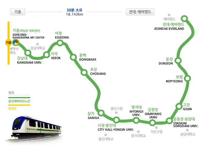
The much-delayed Everline has opened in Yongin, Seoul. It's a fully automated, elevated rapid transit system, connecting the Everland amusement park with the rest of the Seoul Metro System.
There are 15 stations in the initial phase, connecting Giheung station on the Bundang Line to Jeondae-Everland station. There are also stops at various points of interest in Yongin including City Hall-Yongin University.
Yongin, a city neighboring Seoul, has rapidly expanded in the last decade, and is now home to almost 1 million people. The opening of the Everline improves public transportation in the city, adding to the existing DX Line and extension to the Bundang Line.
We're pleased to announce that Explore Guangzhou Metro map is now available free on iPhone! Explore Guangzhou 9.0 includes an up to date metro map, route-planner with times and prices for journeys, integrated Apple/Google/Offline street maps and much more!
The app will now show occasional ads. If you've previously bought Explore Guangzhou you won't see ads, and if you're new to Explore Guangzhou you can try it out for free, or disable ads with a one-off payment of $0.99. We've written an FAQ about ads if you have any questions.
When Apple introduced iOS6 last year, the Google Maps on iPhones and iPads were replaced by Apple iOS Maps. There have been several well-documented issues with iOS Maps, as well as some China-specific issues which we've written about before.
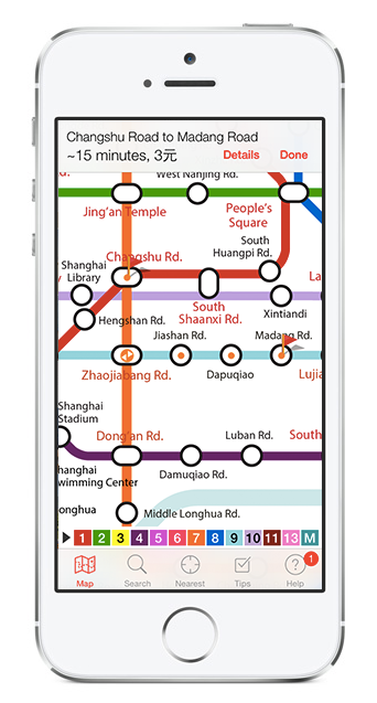
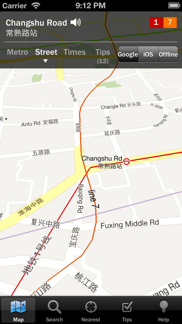
The good news is that today we're launching the latest version v9.0 of our Explore Shanghai Metro map, which now puts the choice back in your hands! Tap on a station, tap "Street" and then you'll have a choice of three options:
Google Maps, including a 3D perspective view (try dragging with two fingers)
iOS/Apple Maps
Offline Maps from Open Street Map
It's another little way we're making our apps Asia's best metro maps :)