By popular demand, you can now drag between two stations to plan a route (this is how route-planning works in the classic version). You can also use the new method of clicking on the first station, choosing "Plan route" and clicking on the second station.
It's also now quicker to plan a new route after planning your first route - no need to dismiss the route-planning bar
Finally, we've improved the caching of the map tiles, so the map should load much faster on repeat visits
We'll continue to work on fixing bugs and making improvements in the beta version until they surpass the classic versions :) If you spot any errors, or have any feedback on how to improve the beta versions, do let me know in the comments, or via our support page.
Since we launched the "beta" versions of our online metro maps a few weeks ago, we've received lots of great feedback from our loyal users. Some people love them, some people have found problems or issues and want to go back to the old versions.
Just to let you know, we are reading and responding to all the feedback, and continuing to make improvements to the beta version. Today we made several improvements to our beta maps for Shanghai, Beijing, Guangzhou, Singapore, Hong Kong and Taipei, including:
The default zoom level shows a larger area
You can now zoom in/out smoothly, rather than only in steps of 2x
When hovering over a station, you'll see a "hand" cursor, making it clearer when you can click
Fixed a bug where flags would disappear during route planning
Faster loading of map tiles in China
To opt-in to the beta version, click the orange banner.
To opt-out and return to the classic version, click the ExploreMetro logo and choose "Don't use beta".
We'll continue to work on fixing bugs and making improvements in the beta version until they surpass the classic versions :) If you spot any errors, or have any feedback on how to improve the beta versions, do let me know in the comments, or via our support page.
To help travelers to Asia's biggest cities, we are running a series of articles on how to travel from major airports to downtown. Today, we're focusing on Guangzhou.
Guangzhou's main airport, Guangzhou Baiyun International Airport (CAN) is situated 28 km north of central Guangzhou.
The simplest way to get to downtown is via Guangzhou Metro Line 3. The station at the airport is named Airport South (Airport North is not yet open). The journey to the city (Tiyu Xilu station) takes about 42 minutes, and a one way ticket costs 7 RMB. Trains run every 7 minutes from 6:10am to 11:00pm.
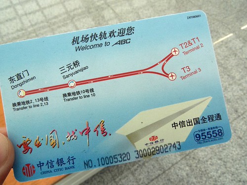
To help travelers to Asia's biggest cities, we are running a series of articles on how to travel from major airports to downtown. Today, we're focusing on Beijing.
Beijing's main airport, Beijing Capital International Airport (PEK) is situated 32 km northeast of central Beijing.
The simplest way to get to downtown is via the Airport Express line. There are stations at Terminal 2 and Terminal 3. The journey to the city takes 16 to 20 minutes, and a one way ticket costs 25 RMB. Trains run every 15 minutes. City-bound trains depart Terminal 3 from 6:21am to 10:51pm and Terminal 2 from 6:35am to 11:10pm.
To help travelers to Asia's biggest cities, we are running a series of articles on how to travel from major airports to downtown. Today, we're focusing on Shanghai.
Shanghai has two main airports: Shanghai Pudong International Airport (PVG) and Shanghai Hongqiao International Airport (SHA). This article covers Pudong Airport, see also our guide to Hongqiao Airport. Pudong Aiport is situated about 30 km east of downtown.
There are two main ways to get to downtown Shanghai by rail. Shanghai Metro Line 2 runs all the way to the airport. Trains run every 8 minutes from the Airport Station between 6:00 and 22:00, and travelling to People's Square takes about 68 minutes and costs 7 RMB. At Guanglan Road station, you'll need to transfer trains, but this is a quick cross-platform interchange. There are numerous interchange stations to other lines, including to Lines 4, 6 and 9 at Century Avenue and Line 1 and Line 8 at People's Square.
A quicker, but more expensive option is to take the Shanghai Maglev Train, the fastest scheduled train journey in the world, with trains running to a maximum speed of 430km/h. Trains depart the Maglev station at the airport every 15 minutes, and take just 7-8 minutes to arrive at Longyang Road station, where you can interchange on to Metro Line 2 or Line 7. A one-way ticket costs 50 RMB, and trains run between 7:02 and 21:42. Note that Longyang Road is not in central Shanghai, it's still approximately 20 minutes to People's Square via Metro Line 2.
To help travelers to Asia's biggest cities, we are running a series of articles on how to travel from major airports to downtown. Today, we're focusing on Shanghai.
Shanghai has two main airports: Shanghai Pudong International Airport (PVG) and Shanghai Hongqiao International Airport (SHA). This article covers Hongqiao Airport, see also our guide to Pudong Airport. Hongqiao Aiport is situated about 13 km west of downtown.
Hongqiao Airport has two terminals, both with a metro station. Terminal 1 station is on Line 10, while Terminal 2 station is on Line 2 and Line 10. On Line 2, trains run every 6-12 minutes and take about 35 minutes to central Shanghai (People's Square station) between 5:35 and 22:50, a ticket is 5 RMB to People's Square. On Line 10, trains run every 10-15 minutes between 5:55 and 22:00. There are numerous interchange stations to other lines on both line 2 and line 10.
We're pleased to announce that the beta version of our new metro maps is now available! Visit our sites for Shanghai, Beijing, Guangzhou, Singapore or Hong Kong - look for this orange banner at the top of the page to opt into the beta:
If you don't yet see the message, please accept our apologies, we will make it available to you soon!
You can also visit our sites from an iPhone, iPad or Android device to try out the beta version.
Some of the great new features of our all-new metro maps include:
Doesn't require Flash
Layout adapts to your browser size
Simplified routeplanning. Just tap on the first station, choose "Plan route", then tap on the second station
Quickly jump to another city using the top menu
Zoom in and out using the mouse scrollwheel or zoom buttons
Pop open the first/last train times panel. Just tap any station, then choose "First & last"
Load the Metropedia article for any station by tapping on the station name
If you'd like to return to the classic version, tap the ExploreMetro logo and choose "Don't use beta".
As this is a beta version, there may still be a few glitches. If you spot anything wrong, or have suggestions for improvements, contact us!
Card Checker is simple to use, simply enter the serial number of your card which is imprinted on the back. The app will connect to the internet and retrieve your most recent balance.
You only need to enter your card number once - after that, simply launch the app and it will immediately fetch your balance.
One caveat: we use official data from the Shanghai Public Transportation Card site, and there can sometimes be a 24-48 hour delay before changes in your balance are reflected in the app.
Since 2007 we've been providing interactive Flash metro maps at exploreshanghai.com and for four other cities. While recently we've been focused on apps for iPhone and Android, our popular online maps at are starting to look a little dated. It's time for a fresh start, so I've been redesigning the online maps from the ground up. The goals of the redesign are:
No more Flash: as an increasing number of devices don't come with Flash Player installed
Make the design responsive - that is to say, it should display well on any screen size, from a mobile phone right up to a large desktop monitor
Allow users of mobile devices who haven't got our native apps to access basic mapping functionality on all devices for free
Add online maps for Seoul and Taipei
Add some features from our native apps, like more intuitive routeplanning, and zoom in/out
We're still testing the new maps, but here's a sneak preview of things to come (click to enlarge):
Soon, you'll be able to opt-in to use the new version when you visit one of our sites. Stay tuned for updates!